Using Satellite Imagery To Map The Impact Of Conflict On Rural Markets In Sudan

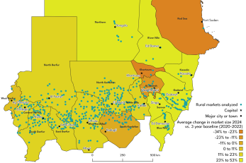
This policy brief details the use of satellite imagery, particularly rural market mapping and NDVI, to understand how conflict in Sudan has affected rural market activity and crop production. It shows that conflict events do have negative, localized impacts on both markets and agriculture, but markets are adaptive and continue functioning with different patterns of trade. Further study is needed, particularly to understand aspects of market activity not observable by satellite – such as terms of trade, price and availability of food, and inclusion of vulnerable groups in markets. However, these initial results point to the usefulness of satellite imagery as one tool to understand fragile and conflict-affected settings, and the need for humanitarian actors in Sudan to understand and engage with local systems and their adaptations in the face of conflict.

